

TOPOGRAPHY : MINES, QUARRIES AND CONSTRUCTION SITES
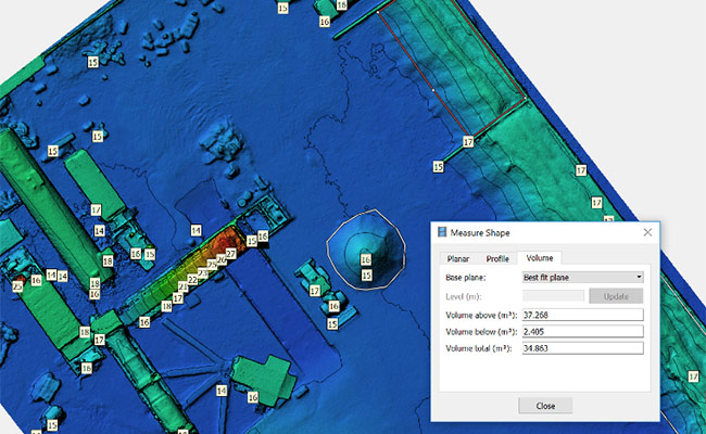
With our UAVs, ROAV7 produces topographic surveys, sites’ 3D models and stock volumes calculations.
The UAVs can quickly cover a huge area thanks to their specific sensors depending on the requested survey and measures :
- 3D modeling of a site
- Stock volume calculations
- Volume analysis of motionless materials to fill or clear out of a site.
UAV TOPOGRAPHY

Added value
UAV topography analysis is more accurate, cheaper and faster than traditional methods, so that we can provide our clients measures as frequently as needed.

Safer
UAV-taken measures prevent employees from being dangerously and for a long time on the site or from climbing moving structures to measure the stock.

Faster
The UAV covers a huge area in a record time. Automated data processing replaces manual traditional processing.

More accurate
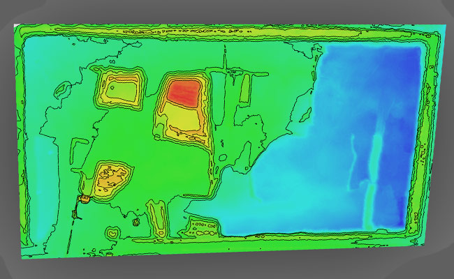
UAV topography enables our clients to globally overview their mines and quarries. We aim at collecting exhaustive, clear and accurate data of the whole facility to produce polygonal 3D models.

Easier to operate
Within a short time and with minimalist equipment, our teams operate on the site in a few hours to cover a huge area.
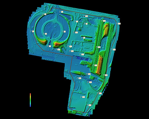
UAV TOPOGRAPHY OF MINES AND QUARRIES
ROAV7 maps public works’ sites such as production deposits, quarries and rubble storage areas. We aim at reducing on-site employees and operation time not to disturb the activity and the production. UAV data collecting enables topography survey for elevation plans, 3D models, water drainage maps and highly-accurate volume calculations.
Thanks to the data digitalisation, our clients can follow in stage the on-site materials quantities through regular operations.
Nowadays, UAV inspection and data processing are the fastest and safest way to estimate aggregate and construction materials volume and calculate quarries’ dimensions.
SEE – ASSESS – DECIDE

No shutdown
No production loss
ROAV7 operates on your high-up areas without interrupting your activity.
Safer
Human risk decrease
Thanks to our UAV inspection, our clients can feel free of human factors from intervening and therefore reducing high-up work hours.
Faster
Remote intervention
ROAV7 can reach the elements of our clients’ interest within a few minutes of flight.
More accurate
Complete overview
ROAV7 collects exhaustive, clear and accurate data on the whole facility.